
Photography as a Hobby for Beginners: Unlock Your Artistic Vision
Photography can be a fulfilling and enjoyable hobby that brings a creative outlet to your


The Comox Valley is a popular weekend getaway for people from Vancouver and the Lower mainland. The area is filled with beautiful waterfalls, hiking trails, wineries and lakes for fishing enthusiasts. One of the most popular destinations in the valley is Browns River Falls. This waterfall is a short drive, about 10 minutes south of Courtenay. The stunning waterfall plunges over a small cliff at a height of 10 feet into the river below. Access to Browns River Falls is fairly easy; it’s about 1 km from the parking area. If taking the Peircy road access.
The falls were accessible by a short hike from the parking lot. The trail is a bit difficult at the end; you will need to use the robe to descend to the falls. But well worth it for the stunning views. You will need to use the rope to slow your descent and provide help climbing back up. It is a rather steep bank (similar to the bluff that leads down into Trent River Falls).
Depending on when you go, parts of the trail may be muddy and slippery, so be sure to wear appropriate footwear.
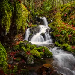
Brown River Falls is a beautiful destination for waterfall photography and nature lovers. It is a special place that shouldn’t be missed by outdoor enthusiasts. The falls span almost 75 feet across and are accessed by a short trail from the parking lot. There are many photo spots along the trail, but the best spot for photos is at the river’s edge.

The falls are a popular destination for swimming. The water is clear, and the scenery is fantastic. Before you visit, it’s a good idea to check the water levels of Browns River Falls. During the summer, the water is usually very low. Visitors can walk to the falls and swim in the pool at the bottom of the falls. During the winter, the water level is quite high, which makes it a much better photo destination.

Browns River Falls is along Brown’s River in the Comox Valley on Vancouver Island, British Columbia.

There are a few ways to get to Brown’s River Falls.
1) If coming from Courtenay take Piercy Road till you come to the power line. There, you will find a small parking lot. In reality, it is the hydro line road, just remember not to park in front of the gate.
Across from the parking lot are K’omoks Treaty Lands and Tribal Park.
2) Take Lake Trail road till you come to Comox Logging Main, follow till you hit Duncan Bay Main. Once on Duncan Bay Main, you will cross the main water lines for the city and the next bridge crosses the Puntledge river. Park on the right after crossing the river. You should see the path from here. It will be a 20-minute walk to get to the falls. NOTE: this might be closed to the public.
The route from Duncan Main is no longer accessible. Well, it wasn’t when I wrote this blog. The city of Courtenay and the developer have been in court for years. I’m not sure at this time if the dispute is over, but the last I read 3L was looking at logging the area. Why take this route? It leads to the other side of the river.
Do not take the Forbidden Plateau Road trail at the bridge. It is private land.
Your photo adventure awaits! Today, we are headed to Browns River Falls, just outside of Courtenay BC on Vancouver Island. We drove down Piercy Road. Till we saw the hydro lines and a small parking spot. Walk along the hydro road for three to five minutes and look for a small hidden path to the right. Follow that path. If you’re lucky, like we were, you’ll see an elderly gentleman sipping beer while perched on a log. He will explain the best way to get there.
You’re only five minutes away from the falls. It’s not a very long walk. The trail starts in the woods, then very quickly you are high above the river bank. It’s a steep hill to go down. Even the dog was hesitant. No need to worry, there is a rope.
Once you’ve descended the slope, Browns River Falls is a beautiful small spot to photograph. We were in luck on this trip. It was a perfect moment to take pictures, the river was raging and high.
Photography can be a fulfilling and enjoyable hobby that brings a creative outlet to your

Welcome to our guide to Photoshop tutorials for beginners: A Complete Beginner’s Tutorial for Learning

Creating stunning images is all about nailing the perfect colour grade. It’s what makes your