What Is Exposure in Photography? A Simple Beginner Guide
Understanding what is exposure in photography helps you control how bright or dark your photos
Show Mom Some Love For Less, Mothers Day Sale – 25% off
One of my favourite quick hikes near Cumberland is the Cumberland China Bowls, also known as the Cumberland Potholes. It’s one of those spots I keep going back to because the hike is short, easy, and always worth it. Once you reach the bowls, the smooth sandstone formations, flowing creek, and tucked-away setting make this one of the most unique short hikes in the area.
If you’re planning a visit, this guide covers everything you need to know, including where to park, how to get there, how difficult the hike is, and what to expect once you reach the potholes.
If you’re visiting the Cumberland China Bowls for the first time, here are the main details to know before you go.
| Details | Facts |
|---|---|
| Distance | 4 Km round trip |
| elevation gain | 80 M |
| Time | 1-2 hours |
| Difficulty | Very easy to easy - walk is a logging road |
| Best time to Visit | Spring or late fall |
| Parking | Sutton Road, Comox lake Road, Recreation Center |
| Facilities | None |
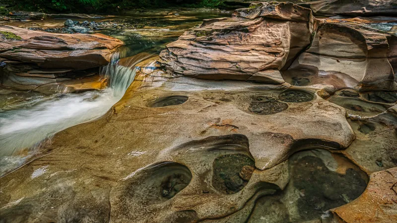
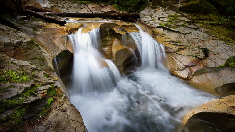
The China Bowls, also called the Cumberland Potholes, are a series of smooth sandstone basins carved out by Perseverance Creek. Over time, the flowing water has shaped the rock into rounded bowls, channels, and polished surfaces that make this area feel very different from a typical forest walk.
That’s what makes this hike so appealing. The trail itself is fairly short and straightforward, but the destination feels unusual and memorable. It’s one of those places that surprises people because the payoff is so impressive for such a relatively easy outing.
This hike is located near Cumberland in the Comox Valley on Vancouver Island. The route is found within the Cumberland Community Forest area and is usually accessed from the trail network near Sutton Road and Comox Lake Road.
If you’re staying in Courtenay or Comox, this is an easy day trip and one of the more popular short hikes in the area. It also works well as part of a half-day outing if you want to combine it with time in Cumberland afterward.
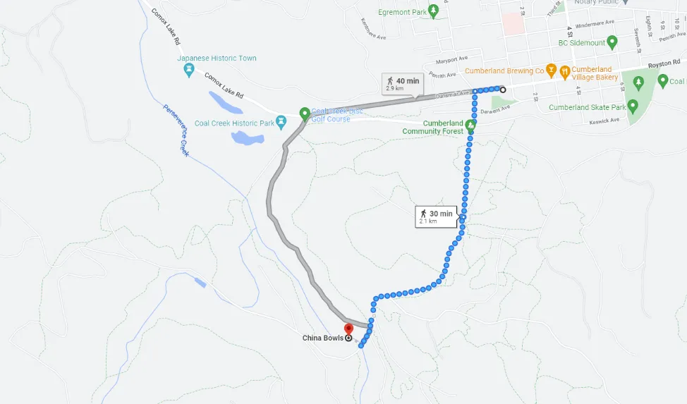
The most common way to reach the trail is from the Cumberland Community Forest entrance near Sutton Road and Comox Lake Road. When I’ve visited, I’ve either parked near the roadside access area or used the overflow parking near the Cumberland Recreation Centre when the closer spots were busy.
From the yellow gate, head into the trail network and turn right onto Davis Lake Main. Stay on the main route and continue until you reach the first bridge over Perseverance Creek. From there, short side paths lead down toward the potholes.
The route is usually easy enough to follow as long as you stay on the main path. It’s a shared-use area, though, so it’s important to stay aware of mountain bikers and other trail users along the way.
Parking is one of the main things people want to know before heading here. The most common options are the roadside area near Sutton Road and Comox Lake Road or the larger gravel lot at the Cumberland Recreation Centre. On busier days, the closer roadside spots can fill up quickly, so having a backup option helps.
On warmer weekends, I’ve found the closer roadside spots tend to fill up first, so the recreation centre is a useful backup
There are no washrooms, garbage bins, or other facilities at the trailhead. If you’re bring water don’t expect washrooms or other services at the site.
This is generally an easy hike, which is part of the reason it’s so popular. The main route is wide, well-used, and not especially demanding. For most people, the walk in feels more like an easy forest outing than a true climb.
That said, the difficulty changes once you reach the creek. The trail itself is simple, but the area around the potholes can be slippery, uneven, and a bit scrambly depending on water levels. In my experience, that’s the part people need to be most careful with. The polished rock can be slick, especially after rain, and it’s easy to underestimate how careful you need to be near the water.
So while I’d still describe this as an easy hike overall, I wouldn’t treat the final section around the potholes casually.
One of the biggest things I’ve noticed from visiting this area multiple times is how different it looks depending on the season.
If you want to see stronger water flow and a more dramatic creek, the wetter months are usually the best time to go. Fall, winter, and spring often give the area a more powerful feel, and the rock formations stand out even more when water is moving through them.
In summer, the water can be much lower and calmer. That can make the area feel more relaxed, but it also means the potholes may look quite different from what you’ve seen online. Lower water levels can make it easier to explore the rock, but the surface can still be slippery, so caution is still important.
For first-time visitors, I’d say it helps to go in with realistic expectations. This is a place that changes with the weather, and that’s part of its appeal.
In my experience, this spot is completely different in the summer months compared to the spring or fall rainy season.
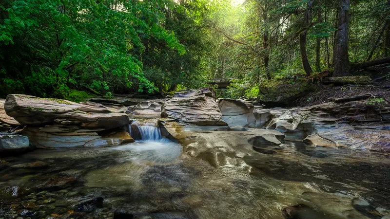
Once you reach the bridge and follow the short path down toward the creek, the landscape opens up into a compact but striking area of sculpted sandstone, flowing water, and rounded bowls carved into the rock.
The destination itself is not huge, but it has a very unique feel. The rock formations are what make this hike worth doing. Depending on the water level, you may see small cascades, smooth channels, and shallow pools formed in the stone.
It’s also a place where you’ll want to slow down and take your time. Even though the hike in is quick, the scenery at the end is the kind of spot where people usually linger. I’ve found that this is one of the reasons the hike feels more rewarding than the trail stats might suggest.
The main trail is wide and fairly approachable, but the pothole area itself is not accessible. Once you leave the main route and move down toward the creek, the ground becomes uneven and the footing is much more challenging.
Dogs are allowed, but I’d strongly recommend keeping them on leash here because of mountain bikers and the slippery rock near the creek. The rock can be slick, there may be steep edges near the water, and it’s simply a safer choice for both pets and other trail users.
There are no washrooms, garbage bins, or other facilities at the trail, so it’s a good idea to pack out everything you bring in.
The main route is wide and fairly approachable, but the final area around the potholes is uneven.
This is a short hike, but it still deserves a bit of preparation.
Wear shoes with good traction. The rock near the creek is the main hazard, especially when it’s wet. Bring water and a light layer, and be extra cautious after rainfall or during periods of higher flow.
Because this is a shared trail system, stay alert for mountain bikers on the approach. It’s also worth checking for any local trail notices or seasonal restrictions before heading out. If you’re visiting with kids, I’d recommend treating the trail as easy but the creek area as a place that needs close supervision.
There are plenty of short walks on Vancouver Island, but this one stands out because the destination feels so unusual. It’s not just a nice forest trail or a simple creek stop. The carved sandstone formations give it a very distinctive look and make it feel like more than a typical easy hike.
That’s why I keep returning. It’s accessible, relatively quick, and still feels rewarding every time. For anyone visiting Cumberland or exploring the Comox Valley, it’s one of the easiest hikes to recommend.
One of the nice things about doing this hike is that it pairs well with time in Cumberland afterward. The village has a lot of character, and it’s worth spending a little extra time there if you can. You can grab coffee or food, walk around town, or explore more of the area’s trail network if you want to turn the outing into a longer day.
Cumberland also has a strong outdoor culture and a lot of local history, so it works well as more than just a quick stop on the way to the hike.
I’ve been back to this spot many times, and it’s still one of the short hikes near Cumberland that I recommend most often. It’s easy to access, doesn’t take long, and leads to one of the more unique natural features in the area.
As long as you come prepared for changing conditions and take care around the creek, it’s a great hike for anyone looking for a short outdoor stop with a memorable payoff.
How long is the hike to the potholes? The hike is about 4 km round trip and usually takes 1 to 1.5 hours, depending on your pace and how long you spend at the creek.
Is the hike to the potholes difficult? The trail is easy overall, but the rock near the water can be slippery and uneven, so extra care is needed near the potholes.
Where do you park for the potholes hike? Most people park near Sutton Road and Comox Lake Road, However I prefer to park at the Cumberland Recreation Centre.

Understanding what is exposure in photography helps you control how bright or dark your photos

I was talking to a fellow photographer the other day, and they mentioned that a

Paradise Meadows Trail — oh, the memories I have of you. When I was younger,