
Photography as a Hobby for Beginners: Unlock Your Artistic Vision
Photography can be a fulfilling and enjoyable hobby that brings a creative outlet to your

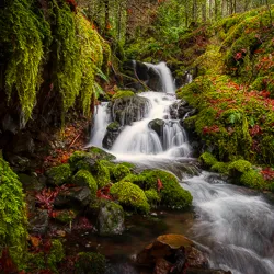


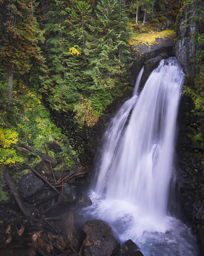

The Lady Falls hike is located in Strathcona Provincial Park on Vancouver Island, British Columbia.
Strathcona Provincial Park is the oldest provincial park in British Columbia. The park was established in 1911. A rough mountain wilderness covering more than 250,000 hectares, Strathcona Park sits almost in the middle of Vancouver Island. It is dominated by mountain peaks, some of which are covered with snow all year long. A landscape studded with rivers, creeks, and streams.
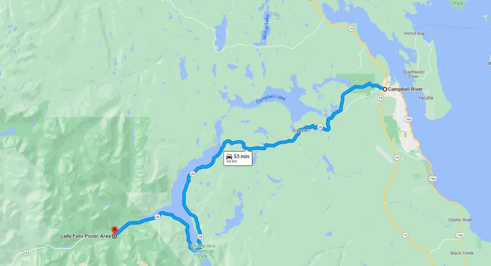
The falls are accessible via a short hike from the Lady Falls Parking Lot.
The Lady Falls Parking Lot is located off of Highway 28, about halfway between Campbell River and Gold River. From the parking lot, follow the signs for the Lady Falls Trailhead. The trail to the falls is an easy 1 km hike through old growth forest.
Lady falls is about a 45 minute drive from Campbell River, a full hour from Comox Valley.
The best way to get to Lady Falls Strathcona Provincial Park is by car. There is no public transportation that goes directly to this area of the park.

This hike difficulty rating is considered easy, with an elevation gain of only 100 metres. The trail is well-marked and suitable for all fitness levels.
The highlight of this hike is the Lady Falls themselves. The falls are best observed after a rainfall when the water flow is at its strongest.
Nearly 30 meters of the water drops to the deep narrow valley below. You might feel the spray of the falls depending on how powerful the falls are when you visit.
The elevation gain for the hike is 100m. This means that there are some uphill sections, but nothing too strenuous. If you need to rest, there are benches made of wood.
The hike’s highest point is at the lookout, where you’ll be rewarded with a breathtaking view!
The Lady Falls is a great way to see Vancouver Island’s amazing scenery. The trail is well-marked and easy to follow.
Be sure to wear proper hiking shoes and bring plenty of water as there are no sources of potable water along the trail. Also, be aware that there may be bears in the area so it’s always best to hike with a friend and make noise while on the trail.
The Lower Myra Falls is located in Strathcona Provincial Park in north Vancouver Island in British Columbia, Canada.
Lower Myra Falls is a beautiful multi-tiered waterfall that cascades down a rocky cliff into a turquoise pool of water. Highlights:
This waterfall hike is a great way to see some of the stunning scenery that Strathcona Park has to offer. The trail to the falls is well-marked and easy to follow. The falls themselves are beautiful, and there are plenty of places to stop and take in the views.
The Lower Myra Falls hike is suitable for all levels of hikers. It is a relatively short and easy hike with only a few minor elevation changes.
Be sure to wear appropriate footwear as the trail can be slippery in places. Also, be sure to bring plenty of water as there is no potable water available along the trail.
Lupin Falls is located in Strathcona Provincial Park on Vancouver Island, British Columbia. The falls are accessible via a short hike from the trailhead, which is located just off of Westwin Mine rd
The falls are best seen after a rainfall when the water flow is at its highest. The falls cascade down a series of rocks and into a small pool at the bottom.
The hike to Lupin Falls is short and easy, making it suitable for all fitness levels. The trail is a circle, take the right trail for the short hike to the falls, if you go left the route is longer and I find a little more enjoyable.
Be sure to wear proper footwear as the trail can be slippery in places. Also, be sure to bring plenty of water as there is no potable water available at the trailhead or along the trail.
There are a few things to keep in mind when hiking to Lupin Falls. First, there is no cell phone reception service in Strathcona Provincial Park, so it’s important to let someone know where you’re going and when you expect to be back. Second, there are bears in the park, so it’s important to be bear aware and carry bear spray with you (just in case). Finally, because the falls are located near a river, there is always a risk of flash flooding. So be sure to check the weather forecast before starting your hike and be prepared for changing conditions.
Karst Creek is located in Strathcona Park on Vancouver Island in British Columbia, Canada.
The highlight of hiking to Karst Creek Falls is the stunning 30-metre (100-foot) waterfall. The falls are best seen after a period of heavy rain but can also be enjoyed during dryer conditions. The trail to the falls is short and easy, making it a great hike for families or those looking for a quick nature fix.
The trail to Karst Creek Falls is short and easy, suitable for all fitness levels. It should take you no more than 30 minutes to reach the falls from the trailhead.
There is a lots of parking lot at the trailhead this area is also a picnic area and boat ramp. The best time to visit Karst Creek Falls is after a period of heavy rain when the waterfall is flowing at its fullest. However, the falls can also be enjoyed during dryer conditions.
If you’re bring a camera you will want to keep it dry. I would suggest bring a camera rain jacket or a make shift clear plastic bag. Prepare your gear before heading out onto the look out. Keep a clean cloth in your pocket so you can wipe the lens. This might also be a good time to use a UV filter. Also wear a rain jacket and hat, you are about to get wet.
We hope you enjoyed this blog post on how to photograph Lady Falls in Strathcona Park on Vancouver Island. For more information on Vancouver Island, be sure to check out our other blog post and our trips. Thanks for reading!
Photography can be a fulfilling and enjoyable hobby that brings a creative outlet to your

Welcome to our guide to Photoshop tutorials for beginners: A Complete Beginner’s Tutorial for Learning
Creating stunning images is all about nailing the perfect colour grade. It’s what makes your