
Photography as a Hobby for Beginners: Unlock Your Artistic Vision
Photography can be a fulfilling and enjoyable hobby that brings a creative outlet to your
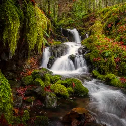


Upper Myra Falls is a scenic hike ending at a large waterfall in Strathcona Provincial Park. The falls are a stunning 23 meter (75 ft ) drop into a deep blue basin.
Hiking Upper Myra Falls takes around 2.5 hours and is moderately difficult with gentle elevation gain.
Upper Myra Falls is a scenic hike that leads to a lookout of a large horsetail waterfall. The hike is longer and separate from the Lower Myra Falls, which makes for a great outing for anyone visiting Strathcona Provincial Park. The hike to Upper Myra Falls takes 2.5 hours, and is moderately challenging. Children should be able to handle the hike without too much difficulty if they are used to hikes of similar distance.
Take the Gold River Highway West out of Campbell River for about 50 km. Keep going straight at the intersection to Gold River. Do not cross the bridge, continue on Westmin Road to the end of Buttle Lake. Continue straight on Westmin Road till you get to the Westmin Mine. Once at the Mine follow the signs post on the road
Follow the directions for Upper Myra Falls driving through the mining site. Parking will be on the right, before the yellow gate.


Across from the parking lot, you find the familiar yellow gate crossing the logging road. Approximately 1.0 km from the parking lot, you will reach the trailhead. Turn onto the trail, and start the ascend to Upper Myra Falls.
The well-kept trail winds its way through the lovely old-growth forest and the typical mossy underbrush of Vancouver Island.
As you follow, the trail there will be slight inclines and descends. Plus, you will need to climb over, under and around fallen logs. Eventually reaching the Upper Myra Falls viewpoint, a little wooden platform with the breathtaking view of the furious 23 m cascade waterfall plunging into the deep blue basin after a bit of climbing.
The Upper Myra Falls trail is a blue-level trail, which means it is intermediate and can be challenging but is still beginner-friendly.
The Upper Myra Falls trail has an elevation gain of 280 meters over the course of 2.5 hours (return trip) and 7.9 kilometers, making it a physically difficult hike for most hikers. However, if you are new to hiking or are fast, this route can be completed in under two hours.

Although there is a 280 meter elevation gains and the start of the trails is difficult because of the roots and rocks. The trail is rated as moderately challenging.
Upper Myra Falls is an unforgettable hiking and photography experience in Strathcona Park on Vancouver Island. The trail is rated as physical difficulty and technical difficulty
The hike can take an average of 2.5 hours to complete, depending on how fast you hike. The best time to visit the trail is between May and September, when it’s less crowded.
The falls are at their strongest in the spring, so if you’re planning to visit in that time of year, be sure to arrive early in the morning or late in the afternoon to catch the best light. If you’re interested in photographing the falls, be sure to bring your tripod and plenty of batteries, as the falls can be quite photogenic.

If you’re looking for an unforgettable hiking and photo experience, Upper Myra Falls trail is definitely worth checking out. The views are incredible and the sense of accomplishment you’ll feel after completing the hike is unbeatable. Just be sure to come prepared with plenty of water and snacks, and to wear proper hiking shoes.
In Strathcona Provincial Park, there is a short hiking route called the Lupin Falls Trail that winds through the forest and passes a cascading waterfall. Families with little children will find it to be the perfect excursion because of the relatively level terrain and short distance. You’ll experience a nice forest ambience along the way and get some superb views of Buttle Lake.
Karst Creek Trail is a 1.3 kilometre hiking loop taking you through a stunning section of Pacific temperate rainforest close to Buttle Lake. The journey through the forest travels across a variety of ground, including rocky creek beds and dirt trails. This makes it a great place for families to explore. A small cascading waterfall is waiting for you at the top of the walk.
Lower Myra Falls is a 1.6-kilometre route near to Campbell River, British Columbia. It takes an average of 30 minutes to complete. Although it is downhill to the lookouts, one must climb back up to the small parking lot. Often a popular swimming hole in summer. It’s best viewed in late winter and spring when the snow is melting.
Photography can be a fulfilling and enjoyable hobby that brings a creative outlet to your

Welcome to our guide to Photoshop tutorials for beginners: A Complete Beginner’s Tutorial for Learning

Creating stunning images is all about nailing the perfect colour grade. It’s what makes your