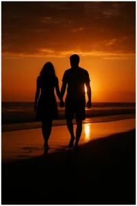
Grand Opening & Black Friday Sale  =  50% Off 

Nile Creek trailhead
Down Arrow

Nile Creek Trail Guide: Difficulty, Map & Directions

The Nile Creek trail is located on Vancouver Island, and is a popular destination for hikers and nature enthusiasts.The trail offers breathtaking views of the old Douglas fir trees, making it a must-visit spot for anyone exploring the island.

Visitors often rave about the picturesque scenery along the trail, with many sharing photos and glowing reviews of their experiences.

Ascend and descend with the trail as you pass through trees covered in moss with various sorts of plants under your every step. Dawn those hiking boots and gaiters, as the trail is always muddy, but well worth the trip. You will be treated to the stunning sight of cascading waterfalls flowing over moss-covered rocks and into the pool below once you reach the falls.

Table of Contents

Where is Nile Creek Trailhead?

There are 2 different areas that you can start the hike from.

From Qualicum Beach

  • Head west on Harlech Rd toward Beach Rd 350 m
  • Turn right onto Beach Rd 350 m
  • Turn left onto Crescent Rd W1.8 km
  • Turn left onto Island Hwy W/BC-19A N15.5 km
  • Turn left onto Charlton Dr

This route is a 10-Km out-and-back trail taking 3 hours to complete. Nile Creek trails is regarded as moderately difficult. Even though it’s a popular hike, you can still find some solitude.

Nile creek trailhead at the 10K mark

Highway 19 – Inland Island Highway

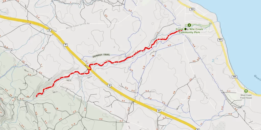
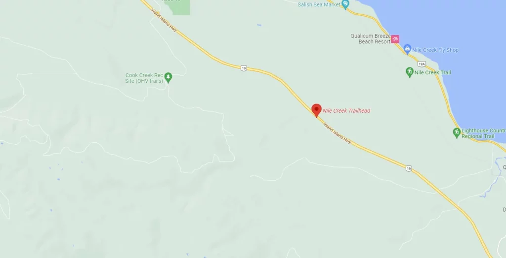
The Island highway passes over the creek . There is parking for 4 vehicles on shoulder of highway 19 before the Nile Creek Bridge, if coming from the south. Descend under the bridge and take the path to your left, through the woods.

Nile creek trailhead at the 1K mark
Click for Google maps

Hiking Nile Creek Trail 

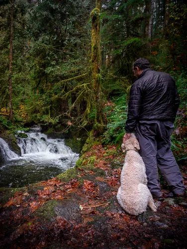
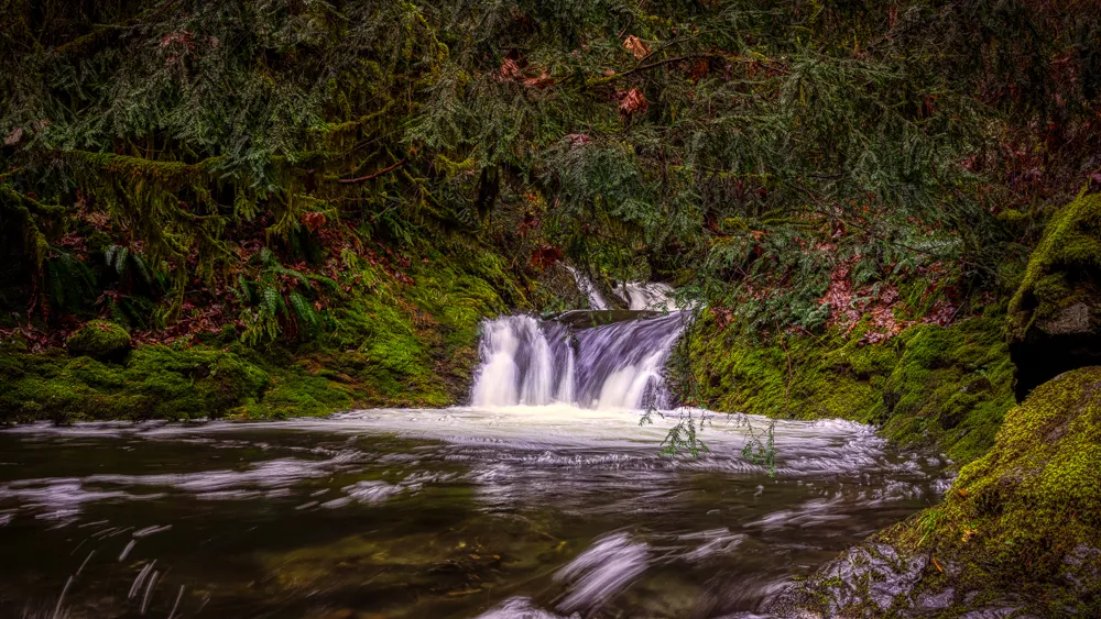
Nile Creek trail is a lovely trek in the old growth-forest. Be prepared to get wet and muddy. There are many mucky areas with fallen trees, rope bridges, and a lot of uphill and downhill travel. This trek isn’t ideal for people with balance or mobility issues. Having said that, the walk is beautiful and lush and features three magnificent waterfalls. The difficulties it poses are well worth it.

Route Description for Nile Creek Trail

  • The Nile Creek Trail is a great place to hike if you are looking for a half-day activity that will transport you to a mystical setting.
  • The falls on the Nile Creek Trail are beautiful and should not be missed.
  • The trail is a challenging but rewarding hike with three waterfalls.
  • The trail is mostly soft wet earth with plenty of exposed roots.
  • The hike is muddy and great for exploring waterfalls.
  • The hike is moderately difficult and long.
  • The hike is great for exploring the area around waterfalls.
  • The hike is great for exploring the area when it is dry.
  • It is advised to bring plenty of water, hiking boots, and trekking poles.

What are the best times to Visit Nile Creek?

The best time to photograph the Nile Creek Trailhead is during the morning or evening hours. During these times, the waterfalls will be illuminated by the sunlight and look beautiful. I personally prefer late Nov or early spring when the water will be at it’s highest.

What Is The Difficulty Level 

How is the Nile Creek Trail? The Nile Creek Trail is rated a 10 with moderate difficulty. It’s a rewarding outdoor adventure perfect for hikers seeking a scenic and moderately challenging experience.

What Is The Distance Of the Trail?

Depending on where you start from the Nile Creek Trail, a stunning, is a 10.3-kilometer loop. There are 2 starting points 1 on the old Island highway and the other on highway 19, which is the shorter route to the falls. 

What Is The Elevation Of The Trail?

The Nile Creek Trail has an elevation of 291 meters (955 feet) with a moderate difficulty. An alternate, easier route has a lower elevation of 162 meters (531 feet)

Nile Creek Trailhead photo

Final thoughts on Nile Creek Trailhead

From the start of the hike at Nile Creek trailhead, you’ll be treated to a variety of different terrains and ecosystems, from old-growth forests, muddy trails, and meadows.

Despite its challenges, Nile Creek hike is worth the effort it has something for everyone. So why not lace up your boots, grab the camera gear and go? You won’t be disappointed.

Nearby trails around Nile Creek Trailhead

Frequently Asked Questions

The main features of this trail include: lush forested environment with numerous natural debris paths, several muddy areas, rope bridges and much up and down; moderate difficulty rating (with definite tricky bits).

You’ll want to arrive well-prepared for this hike as hiking boots and poles are recommended; as is plenty of water and a significant snack. Allow yourself enough time to complete the full 11 – 13 km trek – it’s definitely worth taking your time!

The average time it takes to complete the Nile Creek Trail is about 2.5-4 hours, and the distance is 10 km.

The Nile Creek Trail is a great hike to do all year long, but during the winter it can be tough and muddy. Make sure to wear the proper footwear, I also suggest gaiters, so you don’t get wet or muddy.

Hiking the Nile Creek Trail can be a challenging experience, but with the right gear you’ll be able to make it through. To make sure you’re prepared for this hike, bring along water, snacks, and proper shoes. Make sure to bring a map of the area in case you get lost, and always be aware of your surroundings when hiking in unfamiliar territory.

Yes! There are waterfalls on the Nile Creek Trail.


Our Latest Blogs

Before you go, take a moment to explore Vancouver Island with our interactive map